
GEONIKA GROUPScientific–production group of specialists

Systemic Resource Forecasting (SRF)

A methodology for assessing exploration prospectivity in oil, gas and solid mineral projects.

Oil Gas Metal ores, incl. gold Diamonds Water

The letter of credit is released after the client drills a test well, on the basis of an independent expert’s opinion.

35+ yearsof development of the SRF methodology
2–3 monthstime to results for a 4,000 km² area
4,000 km²minimum area under study
No site visitanalysis does not require an initial visit

From the head of the group

Dear colleagues, ladies and gentlemen!

Before moving on directly to SYSTEMIC RESOURCE FORECASTING (SRF), allow me to briefly touch upon the history of the methodology’s development. Even before the collapse of the USSR, my colleagues and I were working at a specialist institute of the Academy of Sciences of the USSR, which focused on the theory of the origin of mineral deposits. Following the collapse the USSR, my colleagues and I formed a separate group, which we named GEONICA. Whilst studying the origin of mineral deposits, we identified certain common parameters that influenced their formation. We lacked sufficient information and knowledge, so we invited the leading specialists working on Earth-related issues to join GEONICA. We studied virtually all the deposits that had already been discovered and compiled a very extensive database of parameters. We often had to go out into the field to obtain the missing parameters.

Thus, after 15 years of work, we obtained unique information and developed a methodology for processing it. Thanks to the programmers we brought in, a programme was developed which allowed us to determine, fairly quickly, the likelihood of a deposit being present in any area of the Earth. This programme, like the methodology itself, was named SYSTEMIC RESOURCE FORECASTING (SRF). This methodology was tested on a number of sites both in Russia and abroad.

Mikhail Novikov Mikhail Novikov Head of the GEONIKA GROUP
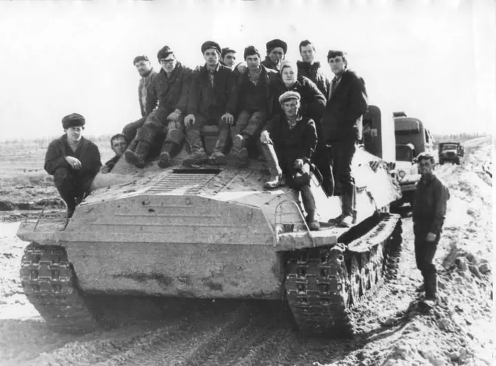
GEONIKA field party
“We often had to go out into the field to obtain the missing parameters.”
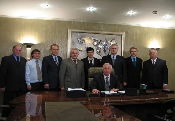
GEONIKA specialists
Specialists of the group and of the research institutes invited to join it.

Market problem

Traditional exploration is capital-intensive and time-consuming

Indicative figures used in international practice.

Traditional exploration is capital-intensive and time-consuming. Seismic surveys, exploration drilling and subsequent data interpretation typically take one to three years and require funding from the earliest project stages, before the risk of a negative result has been removed.

For investors and licence holders, this means a long payback horizon, a high share of sunk costs at the search stage, and limited ability to quickly screen out unpromising areas before capital investment begins.

Exploration timelines vary significantly depending on the type of mineral resource, project stage and methods applied. Indicative figures used in international practice are given below.

Exploration stages — indicative figures
StageDurationIndicative cost
Regional geology and remote-sensing studies3–12 monthsUS$20–500/km²
Airborne magnetic survey1–3 months—
Ground magnetic survey1–6 monthsUS$50–300 per linear km
Electrical/IP survey2–8 monthsUS$300–1,500 per linear km
Exploration drilling6–24 monthsUS$80–500 per metre drilled (diamond drilling significantly more expensive)
Reserves estimation (JORC/NI 43-101 or equivalent)6–18 monthsUS$1–10 million per project

Overall exploration-cycle duration: from the start of exploration to confirmed reserves, the typical timeline is 3–5 years for simple deposits, 5–10 years for most projects, and 10–15 years or more for large or complex projects.

Cost of the exploration cycle per km² of territory. For solid minerals, international practice indicates: early-stage exploration — US$1,000–10,000/km²; detailed exploration — US$20,000–100,000/km²; deposits requiring close-spaced drilling — US$100,000–500,000/km² and above.

For the full exploration cycle — from licence award to confirmed reserves ready for commercial development — international practice is summarised below.

Full exploration cycle — licence award to confirmed reserves
Resource typeAverage full-cycle durationAverage E&A capital expenditureIndicative cost per km² of licence area
Oil (onshore)5–10 yearsUS$20–300 millionUS$50–300 thousand / km²
Oil (offshore)8–15 yearsUS$200 million – 2 billionUS$0.5–5 million / km²
Gas5–12 yearsUS$30–500 millionUS$80–400 thousand / km²
Gold7–15 yearsUS$10–100 millionUS$20–150 thousand / km²
Copper, nickel, polymetallic ores8–16 yearsUS$20–200 million—
Typical full-cycle schedule for oil and gas exploration
StageOilGas
Regional studies0.5–1 year1–2 years
Geophysics1–2 years1–3 years
Exploration drilling1–3 years2–4 years
Field delineation2–4 years2–5 years
Reserves estimation and feasibility study1–2 years1–3 years
Total5–12 years7–16 years

In recent years, the average path from discovery to first production has lengthened to roughly 15–20 years for oil and gas projects and around 16 years for large mining projects, mainly due to increasingly complex geology and more demanding environmental and permitting procedures.

The solution: SRF

Systemic Resource Forecasting

Preliminary assessment of area prospectivity.

Systemic Resource Forecasting (SRF) is a methodology for preliminary assessment of area prospectivity, based on integrated analysis of geological, geophysical and geochemical data on previously identified deposits. The methodology was developed by the GEONIKA GROUP and has been under development for over 35 years.

SRF is applied at the pre-project stage — ahead of fieldwork — as a tool for prioritising areas: narrowing the search zone before conventional exploration is carried out, where the latter is still required in full.

According to the studies conducted, Systemic Resource Forecasting (SRF) makes it possible to obtain, with high reliability, the coordinates of deposits, where such deposits are present within the surveyed area.

Principle of operation

Statistical-pattern analysis of known deposits

The area under study is not less than 4,000 km².

The methodology is based on statistical-pattern analysis of the distribution of known oil, gas and ore deposits, drawing on data from adjacent disciplines: seismology and tectonics, the geomagnetic field, geochemistry, stratigraphy and palaeontology, as well as the landscape and climatic characteristics of the territory.

Data processing is carried out using specialised software that defines the area under study (not less than 4,000 km²) and estimates the probability of a deposit being present within its boundaries.

The output of SRF is a map of prospective zones with the coordinates of the exploration target, as confirmed by numerous studies conducted. Selected client feedback is attached.

The final accuracy depends on the quantity and quality of source data available for the region and must be confirmed by subsequent fieldwork.

Because rights to the use of Systemic Resource Forecasting (SRF) are practically impossible to protect through conventional IP mechanisms, it was decided to give SRF the status of trade secret (know-how). For this reason, the GEONIKA GROUP does not maintain a website, and the group’s contact details are not publicly available. However, we can always be reached by e-mail.

Disciplines drawn upon

Seismology and tectonicsGeomagnetic fieldGeochemistry StratigraphyPalaeontologyLandscape and climate
Output — map of prospective zonesSRF
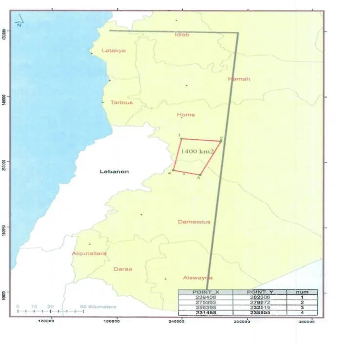
PointXY
1239 408282 306
2275 363278 872
3256 398232 519
4231 458236 855

Illustration of the output format. The coordinates shown are those of the Syrian test-site outline published in the 2022 conclusion.

Advantages

What the methodology changes

  1. Shortens the pre-project assessment timeline through analysis that does not require an initial site visit. Data for a 4,000 km² area can be obtained within 2–3 months.

  2. Reduces the risk of investing in areas that turn out to be unpromising, before capital-intensive fieldwork begins. Unpromising areas are excluded from the project.

  3. Allows prioritisation of multiple areas in a portfolio before budget is allocated to conventional exploration.

  4. Used in combination with classical methods rather than as a replacement for them — SRF narrows the search zone, with final confirmation remaining a matter for drilling.

Economic effect

Cost and time to results

The cost of applying SRF averages US$14,000 to US$18,000 per square kilometre.

Time to results: 2–3 months.

US$14,000–18,000per square kilometre
2–3 monthstime to results
4,000 km²minimum area under study

Practice of application

Testimonials on the use of SRF

The methodology has been applied by the GEONIKA GROUP across a number of areas in Russia and abroad.

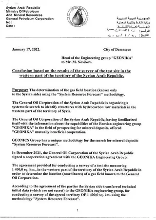
Conclusion of the General Petroleum Corporation, 17 January 2022 Original · EN
Damascus · 17 January 2022

Conclusion based on the results of the survey of the test site in the western part of the territory of the Syrian Arab Republic

General Petroleum Corporation · Ministry of Petroleum and Mineral Resources of the Syrian Arab Republic

The Syrian side supplied non-secret technical data and asked GEONIKA to determine the coordinates of a gas field known only to them. Working from the desk, without visiting the territory, SRF returned the location of two gas fields with reserves of more than 10 billion cubic metres each, and of one smaller field.

Test site
1,400.0 sq. km
Deadline set
3 months from signing
Result
Two gas fields over 10 bcm
Visits to the site
None
Full text of the conclusion

Purpose: The determination of the gas field location (known only to the Syrian side) using the “System Resource Forecast” methodology.

The General Oil Corporation of the Syrian Arab Republic is organizing a systematic search to identify structures with hydrocarbon raw materials in the western part of the territory of Syria.

The General Oil Corporation of the Syrian Arab Republic, having familiarized itself with the information about the capabilities of the Russian engineering group “GEONIKA” in the field of prospecting for mineral deposits, offered “GEONIKA” mutually beneficial cooperation.

GEONICS Group has a unique methodology for the search for mineral deposits “System Resource Forecast”.

In December 2021, the General Oil Corporation of the Syrian Arab Republic signed a cooperation agreement with the GEONIKA Engineering Group.

The agreement provided for conducting a survey of a test site measuring 1 400,0 sq. km., in the western part of the territory of the Syrian Arab Republic in order to determine the location (coordinates) of a gas field known to the General Oil Corporation.

According to the agreement of the parties the Syrian side transferred technical initial data (which are not secret) to the GEONIKA engineering group, for conducting a survey of the agreed territory OF 1 400,0 sq. km. using the methodology “System Resource Forecast”.

The GEONIKA engineering group, in accordance with its declared capabilities in the sphere of field prospecting, was tasked using its “System Resource Forecast” methodology to determine within 3 months from the date of signing the Agreement the location (coordinates) of a gas field unknown to the GEONIKA group (without physically visiting the test site).

On January 17, 2022, GEONIKA specialists presented to the General Oil Corporation of the Syrian Arab Republic the results of a survey of a test site measuring 1,400.0 sq. km. indicating the exact location (coordinates) of a gas field previously unknown to the GEONIKA group.

During the survey of the test area of 1 400,0 sq. km. in the western part of the territory of the Syrian Arab Republic, the specialists of the GEONIKA group did not visit the surveyed territory.

As a result of the survey of a test site measuring 1,400.0 sq. km., the location of two gas fields with reserves of more than 10 billion cubic meters of gas and one field with reserves of less than 10 billion cubic meters of gas was determined. To determine the location of deposits with reserves of less than 10 billion cubic meters of gas, it is necessary to use a 1:50,000 scale magnetic survey.

The General Oil Corporation, evaluating the results of the survey of the Syrian territory and determining the exact location (coordinates) of a gas field previously unknown to the GEONIKA Group, confirms the uniqueness and high efficiency of the capabilities of the “System Resource Forecast” methodology.

The General Petroleum Corporation states and confirms that the “System Resource Forecast” methodology can be used in the search for hydrocarbon deposits on the territory of the Syrian Arab Republic.

General Petroleum Corporation. General Director, Doctor of Technical Sciences — Nabih Khristin.

Reproduced from the original conclusion issued in English. Scan available on request.

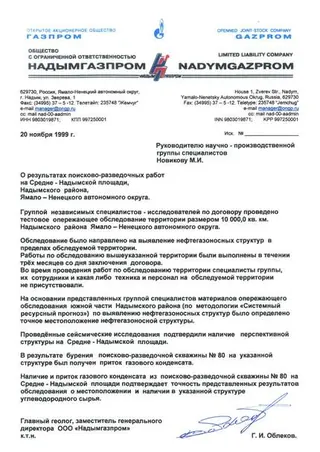
Letter of Nadymgazprom, 20 November 1999 Original · RU
Nadym · 20 November 1999

On the results of prospecting and exploration works at the Sredne-Nadymskaya area, Nadym district, Yamalo-Nenets Autonomous Okrug

Nadymgazprom LLC · Gazprom · Yamalo-Nenets Autonomous Okrug, Russia

An advance survey of 10,000 sq. km was carried out under contract, with no specialists, equipment or personnel of the group present on the territory. Seismic studies confirmed the structure identified, and exploration well No. 80 produced an inflow of gas condensate.

Territory surveyed
10,000.0 sq. km
Time taken
3 months from contract
Independent check
Seismic surveys
Result
Gas-condensate inflow, well No. 80
Full text of the letter — translation from Russian

To the Head of the scientific and production group of specialists, M. I. Novikov. On the results of prospecting and exploration works at the Sredne-Nadymskaya area, Nadym district, Yamalo-Nenets Autonomous Okrug.

A group of independent specialists-researchers carried out, under contract, a test advance survey of a territory measuring 10,000.0 sq. km of the Nadym district of the Yamalo-Nenets Autonomous Okrug.

The survey was aimed at identifying oil- and gas-bearing structures within the surveyed territory. The works on the survey of the above territory were carried out within three months of the date of conclusion of the contract. During the works on the survey of the territory, the specialists of the group, their staff and any equipment or personnel were not present on the surveyed territory.

On the basis of the materials of the advance survey of the southern part of the Nadym district presented by the group of specialists (using the “Systemic Resource Forecast” methodology) for the identification of oil- and gas-bearing structures, the exact location of an oil- and gas-bearing structure was determined.

The seismic studies carried out confirmed the presence of a prospective structure at the Sredne-Nadymskaya area.

As a result of drilling prospecting and exploration well No. 80 at the said structure, an inflow of gas condensate was obtained.

The presence and inflow of gas condensate from prospecting and exploration well No. 80 at the Sredne-Nadymskaya area confirms the accuracy of the presented survey results as to the location and the presence of hydrocarbon raw materials in the said structure.

Chief Geologist, Deputy General Director of Nadymgazprom LLC, Cand. Sc. (Eng.) — G. I. Oblekov.

Translated from the Russian original. The scan of the original letter is shown alongside and is available on request.

Test site plan, western Syria
Test site of 1,400.0 sq. km in the western part of the territory of the Syrian Arab Republic, with the coordinates of the four corner points. From the conclusion of the General Petroleum Corporation, 17 January 2022.

Cooperation model

Work with a client is structured as follows

  1. The client enters into an agreement with the authorised representative of the SRF methodology rights holder (for Europe and international projects — Helvic Enterprises AG, Zug, Switzerland). The form of agreement is negotiated separately between the parties.

  2. GEONIKA carries out a survey of the site proposed by the Client.

  3. Payment under the contract is made by letter of credit for the full contract amount. The letter of credit is released after the client drills a test well, in the presence of an independent expert agreed by the parties and the client’s bank, on the basis of that expert’s opinion.

Payment is released on confirmation, not on delivery of a report

The full contract amount is placed under a letter of credit at signature. It is released only after the client drills a test well, in the presence of an independent expert agreed by the parties and the client’s bank, on the basis of that expert’s opinion.

Invitation to cooperate

Open to cooperation

For more than 35 years, the GEONIKA GROUP has been developing the SRF methodology together with specialists from leading research institutes, and is open to cooperation with companies in the oil and gas, mining and exploration sectors seeking to accelerate and reduce the cost of pre-project assessment of prospective areas.

Sincerely,

Mikhail Novikov Mikhail Novikov Head of the GEONIKA GROUP
Contact

You can always contact us by email

Helvic Enterprises AG · Zug, Switzerland
Authorised representative of the SRF methodology rights holder for Europe and international projects.

By sending this request you agree to the processing of the data submitted for the purpose of replying to it. Nothing is shared with third parties.